

THE VISION
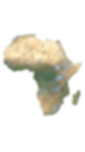
By 2035, in partnership with local communities, governments, researchers and NGOs, The Wilderness Project aims to explore, study and better protect 1.2 million square kilometres of irreplaceable African wilderness. Central to this effort is to establish detailed baselines of the largely undocumented sources and watersheds of Africa’s greatest river basins – Okavango, Zambezi, Congo, Nile, Chad and Niger. We will do this by following the Great Spine of Africa (GSoA), the geographical linkage between the water towers that feed sub-Saharan Africa.

THE URGENCY
From their sources to their ends in deltas or swamps, these six major river basins not only support some of the most biodiverse ecosystems on the planet, but drinking water and irrigation to more than 400 million people. These systems have long remained undervalued, underserved and exploited to the benefit of outsiders. Threatened by rapid and unsustainable development, Africa’s last wild rivers are being crippled by deforestation, mining, fires, pollution and dams. Due to the inaccessibility and remoteness of the Great Spine, there is a dearth of scientific data. This knowledge will be our best defence in combating the devastating effects of climate change.

DR. STEVE BOYES
"In the science we seek truth and understanding.
In the storytelling we seek impact and meaning."
HOW WE DO IT

Research Expeditions
Using mekoro and canoes we have accessed and navigated over 16,000km of Africa's remotest river landscapes. In the next decade we will conduct transects of a further 45,000km, where we aim to collect data using several standard research methods. Leveraging technologies such as satellite imagery and AI, the data is used to assess river health within a given river system, across basins and over time. This process enables the development of a River Health Index that can inform and guide immediate next steps, long-term policy and community conservation decision-making.

Community Programmes
Our conservation work would be impossible without the support of local communities. They are our local experts, with cultural beliefs and traditions moulded by the rivers they depend on and deep knowledge that is key to protecting wild areas. We work closely with communities to help facilitate livelihood and enterprises that benefit them and are suited to the environment they live in. To this end we are constantly seeking out and working with local partners and entities who can collaborate with us across multiple sectors.

Storytelling
Producing world class documentaries, podcasts and other forms of conservation media is a critical facet of achieving our long-term goal of driving momentum for better protection of nature. Through communicating the science and community histories and cultures, we aim to show the opportunities and challenges in these remote and undervalued wildernesses. Key to this mission is nurturing a network of local storytellers to produce media from highly localised and oft-neglected perspectives.
SPONSORS & PARTNERS